

TVApps.com
This website has been temporarily re-deployed to give info on the Carnation Tall Ugly Cell Tower proposal.
Info & Alternate Proposal
In the event of a Dam break, one tall cell tower will not provide enough
user capacity and the system will fail. The resulting confusion
will cause people to die. In the case of a Dam break, everyone
will be WhatsApping and FaceTiming with their relatives (each taking
1Mbps (#1)). People watching news channels will exacerbate the
problem. One cell tower using 4G or Low-Speed-5G can only provide
capacity for about 100 of such calls (#2), but on a Summer's day there
may well be 6,000 people in town (of which 3,000 are at Remlinger), so
4G or Low-Speed-5G can only handle 2% of the demand. Having a tall
cell tower does not help, as the capacity is a function of carrier
frequency, not height. High-Band-5G (#3) can handle the data capacity,
but High-Band-5G can only do that if you are less than a Quarter mile
from the antenna. That's why new 5G towers are typically only 50
feet tall and you need lots of them. To avoid the cell towers
interfering with each other it is necessary to have each tower cover
just a small area. A tall tower will prevent any smaller towers
added in the future from working properly because it will swamp them.
There is no chance that the north end of town will get proper 5G from a
cell tower by the water tanks (it is very badly sited to do that).
Certainly a tower is not needed as antennas can be mounted on the
existing water tanks (CMC 15.98.080, CMC 5.98.050).
The solution
is three 50 foot cell antennas in town, each doing Mid-Band-5G (#3). One
on the water tanks serving the east of town, one serving the north of
town, and importantly one on or near the Tolt bridge serving Remlinger,
Tolt MacDonald park, and the new houses by the firestation. It is
vitally important that Carnation has a state-of-the-art communication
system.
In early 2019, the Federal Communication Commission (FCC)
issued a declaratory ruling which directs local jurisdictions to promote
the adoption of 5G wireless services using a network of small cell poles
rather than cell towers. The FCC wants "Small Wireless Facilities"
which are defined as 50 foot or less height. Sammamish council are
enlightened and have fully embraced the FCC directive, and now have a
state-of-the-art communication system...
https://sammamishwa.civicweb.net/document/56053/An%20ordinance%20of%20the%20City%20of%20Sammamish,%20Washingt.pdf?handle=B63CED2853124C39ACFC05410910AB34
.
The business choice of a tall tower inherently means a business
choice of Low-Speed-5G. This provides a very small pot of data bandwidth
(less than 100Mbps) but it covers a wider area so more people will be
fighting over the small pot of data.
T-Mobile mistakenly
purchased lots of low frequency spectrum that can only support
Low-Speed-5G (#3). Once they realized that Low-Speed-5G would not be
good enough, they purchased Sprint because Sprint owned Mid frequency
spectrum. T-Mobile can now do Mid-Band-5G, but they are still left with
the embarrassment of owning the Low-Speed-5G spectrum. What they are
trying to do is palm-off the Low-Speed-5G on unsuspecting small town
jurisdictions. Carnation must NOT for fall for this con-trick and must
demand at minimum Mid-Band-5G (using 50 foot antennas) to give the data
bandwidth the town needs.
(#1) Data Requirements
Video chats
like FaceTime need 1-4 Mbps
https://cdelightband.com/news/how-much-internet-speed-do-i-need/#:~:text=Video%20chats%2C%20such%20as%20Facetime,are%20sending%20a%20quality%20video ).
Let's be conservative and call it 1Mbit/sec.
Even when there isn't an
emergency, typical cellphone usage is 1 GBytes per day per phone.
(#2) 4G Data capacity
4G LTE networks use less than 6GHz and can
provide theoretical peak speeds up to 100 Mbps (That's about 100 people
doing WhatApping or FaceTiming, ie less tha 2% of the people in town).
https://www.ni.com/en/solutions/semiconductor/wireless-infrastructure-development/how-cell-towers-work.html#:~:text=5G%20cell%20towers%20can%20deliver,10%20Gbps%2C%20a%20hundredfold%20increase
(#3) 5G Data Capacity
There are actually three different things
that get called 5G. High-Band-5G can provide speeds of up to 10,000 Mbps
(using up to 300GHz). Mid-Band-5G uses much lower frequency spectrum
(between about 2.5GHz and 30GHz) and can provide speeds of 300 Mbps to
1,000 Mbps. Then there is Low-Band-5G (aka Low-Speed-5G) which is a
complete marketing con-trick that makes people think they have 5G even
though the data bandwidth is typically less than 100 Mbps (not much
different from 4G) and only uses about 0.6 GHz. Low-Speed-5G is only
enough to serve about 100 people WhatsApping or FaceTiming. High-Band-5G
is ideally what's needed to support the 6,000 people that can be
in-town, but High-Band-5G is only able to provide that data bandwidth if
you are less than a quarter of a mile from the antenna (because the high
frequency gets highly attenuated even with clear line on site,
especially if the air is moist). For a rural town, Mid-Band-5G is an
acceptable compromise between data bandwidth a distance.
https://venturebeat.com/mobile/the-definitive-guide-to-5g-low-mid-and-high-band-speeds/#:~:text=One%20low%20band%20(600%2D700MHz,ranges%20from%20100%20to%20900Mbps .
https://www.quora.com/How-far-can-5G-radiation-travel?no_redirect=1
https://www.businessinsider.com/5g-high-speed-internet-cellular-network-issues-switch-2019-4
https://www.tutela.com/blog/spectrum-analysis-merging-t-mobile-and-sprint-will-create-a-formidable-competitor#:~:text=Sprint%20holds%20nearly%2080%20percent,capacity%20in%202500%20MHz%20nationwide .
Added advantages of my proposed
Mid-Band-5G plan are:
1) The city will
get more revenue, because the city owns the structures (eg water towers,
alarm poles, consented poles in new developments, etc), so can
independently rent space to other operators, and there will be more
antenna sites. If T-Mobile own the structure (ie a tall ugly cell tower)
they are in the driving seat regarding how much eg Verizon has to pay
them to be on their mast.
2) A decent proportion of Carnation
households will be able to cancel their Comcast monthly bill as their 5G
cellphone plan will also be able to provide their home WiFi internet
needs.
3) This is in addition to the fact that in the event of a
Dam break, people who are at work will be able to contact their families
in Carnation for reassurance, so will be much less likely to start madly
driving INTO Carnation, causing road congestion.
The T-Mobile
tower only benefits T-Mobile (their coverage map used to sell phone
plans, and they get to use their embarrassing low speed spectrum) - it
does not benefit Carnation city revenue, and it certainly does not
benefit Carnation residents.
Say NO to a Tall Ugly Cell Tower.
Instead say Yes to better cellphone performance (that works if the Dam
breaks) and gives better internet.
Demand Mid-Band-5G.
Other problems with the Current Proposal
There are several problems with this CUP which I believe require denial of the permit.
First, per CMC 15.98.080 and 15.98.050 (below), a documented effort to identify and place the antennas on an existing structure is required. There is no evidence in the record that this requirement has been met. The utility poles along the Snoqualmie Valley Trail and utility poles along Tolt River Road (Entwistle) are potential existing locations, and other locations may be found if the required investigation is undertaken.
15.98.080 - Development standards for freestanding WCF with support structures.
-
Placement of a freestanding WCF shall be denied if placement of the antenna(e) on an existing structure can accommodate the operator's communication needs. The collocation of a proposed antenna(e) in an existing support structure shall be explored and documented by the operator in order to show that reasonable efforts were made to identify alternative locations.
-
The applicant shall demonstrate that the proposal location was selected pursuant to the siting criteria established in this chapter. WCF support structures shall be denied if an alternative placement of the antenna(e) on a building or other existing structure can accommodate the communication needs. Applicants shall be required to provide documentation that reasonable efforts to identify alternative locations were made.
5.98.050 - General siting criteria.
-
Siting criteria for WCFs is necessary to encourage the siting of those facilities in locations most appropriate based on land use compatibility, neighborhood characteristics, and aesthetic considerations. No general siting criteria are necessary for small satellite dishes or amateur radio towers because these facilities are allowed within all zoning districts.
-
Generally, collocating on existing WCF towers is encouraged by fewer standards and less complex permit procedures. Further, attachment of antenna(e) to existing nonresidential structures and buildings primarily within light industrial and commercial zoning districts is preferable to new WCF support structures. The city may request feasibility studies which demonstrate that locations on existing structures have been explored as the preferred siting alternative.
Second, per CMC 15.98.120 and CMC 15.18.020 (below), “the following items shall be required for a WCF application” but are not in the record: A diagram or map showing the visual impact within a minimum of 500 feet, a map showing the service area of the WCF and an explanation of the need at the proposed site, technological evidence that the height has been kept to the minimum height necessary, a site plan showing the specific placement of the WCF on the site (where are the property lines?), photo simulations of the proposed facility from effected residential properties and public rights-of-way at varying distances, a site plan showing existing grades, and a vicinity map. It is difficult or impossible to evaluate the proposal with this required information missing.
15.98.120 - Application submittal requirements.
In addition to the information requested in the conditional use permit application of Section 15.16.040 of this code, the following items shall be required for a WCF application:
-
A site plan which shows existing and proposed transmission structures, warning signs, fencing and access restrictions;
-
A diagram or map showing the visual impact of the proposed structure on that area within a minimum radius of five hundred feet from the site;
-
A map showing the service area of the proposed WCF and an explanation of the need for that facility at the proposed site. The explanation shall also include technological evidence that the height of the proposed facility is the minimum height necessary to fulfill the WCF's function.
-
A site/landscaping plan showing the specific placement of the WCF on the site; showing the location of existing structures, trees, and other significant site features; and indicating type and locations of plant materials used to screen WCF components and the proposed color(s) for the WCF.
-
Photo simulations of the proposed facility from effected residential properties and public rights-of-way at varying distances.
15.18.020 - Applications submittal requirements.
-
Subject to subsections C and D of this section, applicant submittal requirements are as follows:
-
3. A site plan of the proposed project, at a scale determined by the city planner, showing the following on one or more sheets as needed for readability:
-
3.b. Existing and proposed grades,
6. A vicinity map, showing the location of the site in relation to nearby streets and properties;
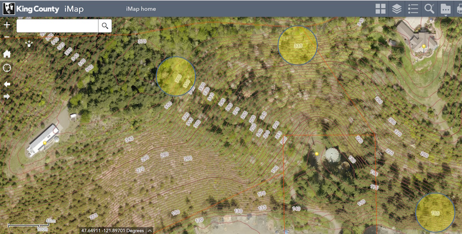
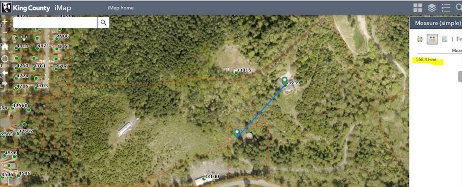
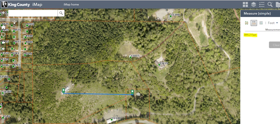
Third, per CMC 15.98.130 (below), the cell tower must comply with FCC OET Bulletin #65. The consultant report (Evaluation of Compliance with FCC Guidelines for Human Exposure to Radiofrequency Radiation) does not evaluate important instances of human exposure because it was done for ground level exposure. There are 2 close residences at (nearly) the same elevation as the top of the mast. But according to the report, “This report analyses (sic) the cumulative RF exposures from the proposed T-Mobile antennas at ground level.” This analysis is inadequate for residences at the same level as the top of the mast given the usual antenna radiation pattern pointing at the horizon or slightly down. Using King County iMap for the following distance and elevation measurements (see maps below), the ground level of the mast base is 165’ above sea level (ASL). Combine that with the mast height of 155’ and the antennas are 320’ ASL. The 2 close residences are 550 and 850 feet from the antennas, at elevations of 340’ ASL and 360’ ASL, or about 20’ and 40’ above the top of the mast. The full transmitted RF radiation will have a direct horizontal line into the closest residence just 550 feet away. This requires a completely different analysis from the ground level calculations.
15.98.130 - Radio frequency standards.
-
The applicant shall comply with federal standards for radio frequency emissions. Within six months after issuance of its operational permit, the applicant shall submit a report which provides cumulative field measurements of radio frequency emissions of all antennas installed at the subject site and demonstrates compliance with established Federal standards; in particular, adherence to FCC OET Bulletin #65—RF Exposure Guidelines for Human Exposure to Radio Frequency Electromagnetic Fields. If on review, the city finds that the WCF does not meet federal standards, the city may revoke or modify the conditional use permit.
Map showing the elevation of 2 same-level residences and the base elevation of the tower
Map showing the distance to the closest same-level residence
Map showing the distance to the second closest same-level residence
Fourth, the Notice of Application and various other documents state “The Anchor Tenant will be T-Mobile with space available for three additional wireless carrier colocations“. These three additional carriers are not taken into consideration in the Evaluation of Compliance with FCC Guidelines for Human Exposure to Radiofrequency Radiation. The calculated radiation should be multiplied by 4 to account for the planned future radiation from colocated antennas. The factor of 4 is essential for any conclusion about the safety of the towers, particularly for residences at the level of the antennas. The CUP should be denied if the RF radiation received by the residences at the mast height will be unsafe.
Fifth, the cell tower is much too close to neighboring property lines. A typical setback for cell towers is one foot for each foot of height. For example, King County 21A.26.050 (below) requires this (so a 155’ setback). The same setback (155’) is true for Duvall per 14.56.070 (below). Since the proposed location is surrounded by residential zoning, allowing less setback than the established standard (set by other governmental jurisdictions in the area) is not justified given the intended protections from cell towers for residential properties in the Carnation Municipal Code (protections discussed in the next item).
King County 21A.26.050 Setback requirements. Except as outlined for modifications and consolidations pursuant to K.C.C. 21A.26.140 and 21A.26.150 or when setbacks are increased to ensure compliance with NIER exposure limits, communication facilities shall comply with the following setbacks:
-
Transmission structures, other than those for minor communication facilities, that exceed the height limit of the zone in which they are located shall be set back from property lines either a minimum of fifty feet or one foot for every foot in height, whichever results in the greater setback, except:…
Duvall 14.56.070 - Development standards for freestanding wireless communication facilities.
-
Facilities adjacent to a single-family zone shall be set back a distance equal to the height of the wireless communications support structure from the nearest single-family lot line.
Sixth, a 155’ cell tower is unsightly (CMC 15.98.010.A) and not aesthetically appropriate (CMC 15.98.050) for the surrounding residential zoning. This is not a subjective determination. Rather, it is an objective determination based upon the CMC. Almost the entirety of CMC 15.98 is written to mitigate “the unsightly characteristics associated with wireless communications facilities and to encourage creative approaches in locating wireless communications facilities which will blend in with the surroundings of such facilities “(CMC 15.98.010.A). Additionally, the approval conditions for a CUP, found in CMC 15.80.040, require the proposed use is “designed … in a manner that is compatible with the existing or intended character, appearance, quality of development and physical characteristics of … the surrounding vicinity.”
So what is “the existing or intended character, appearance, quality of development and physical characteristics of … the surrounding vicinity”? The surrounding vicinity is all residences. Cell towers are not allowed in residential zones (CMC 15.98.160). A proposal for a 155’ tower in the middle of surrounding residences cannot meet the requirement for compatibility in CMC 15.80.040.
Below are some of the ways the CMC regulates WCFs. These regulations objectively support the conclusion that a cell tower is unsightly and the proposal is not compatible with the surrounding vicinity.
-
The purpose of this chapter is to establish appropriate locations, site development standards, and permit requirements to allow wireless communications facilities within the city, in a manner which provides for locations and options for wireless communication providers while minimizing the unsightly characteristics associated with wireless communications facilities and to encourage creative approaches in locating wireless communications facilities which will blend in with the surroundings of such facilities.
-
The goals of this chapter are to: (1) encourage the location of towers in non-residential areas and minimize the total number of towers throughout the community; (2) encourage strongly the joint use of new and existing tower sites; (3) encourage users of towers and antennas to locate them, to the extent possible, in areas where the adverse impact on the community is minimal; (4) encourage users of towers and antennas to configure them in a way that minimizes the adverse visual impact of the towers and antennas; and (5) enhance the ability of the providers of telecommunications services to provide such services to the community effectively, efficiently, and in a timely manner.
15.98.050 - General siting criteria.
-
Siting criteria for WCFs is necessary to encourage the siting of those facilities in locations most appropriate based on land use compatibility, neighborhood characteristics, and aesthetic considerations. No general siting criteria are necessary for small satellite dishes or amateur radio towers because these facilities are allowed within all zoning districts.
-
Generally, collocating on existing WCF towers is encouraged by fewer standards and less complex permit procedures. Further, attachment of antenna(e) to existing nonresidential structures and buildings primarily within light industrial and commercial zoning districts is preferable to new WCF support structures. The city may request feasibility studies which demonstrate that locations on existing structures have been explored as the preferred siting alternative.
15.98.060 - Permitted locations
-
Attached WCFs may be mounted on all currently existing nonresidential buildings except as follows:
-
Any building which is an accessory structure to a residence;
-
Buildings that would be visually dominated by the WCF;
-
Within five hundred feet of any school.
-
Attached WCFs mounted on existing nonresidential buildings must meet the following conditions and criteria:
-
A WCF may consist of one of the following:
-
- Attached WCFs mounted on existing nonresidential buildings must meet the following conditions and criteria:
-
Up to four nonreflective panel antennas or up to nine nonreflective panel antennas if the applicant demonstrates necessity to the satisfaction of the city. No one antenna shall exceed four hundred eighty square inches and the total of the combined antennas shall not exceed one thousand four forty square inches of surface area; or
-
Up to three whip antennas; or
-
One nonreflective parabolic dish one foot or less in diameter.
-
In the event of collocation, more than one of the facilities described above may be included.
-
The antennas must conform to the following height restrictions relating to the existing building:
-
Five feet measured to the top of a panel antenna above the roof proper of the existing building at the point of attachment;
-
Ten feet measured to the tip of the whip antenna above the roof proper of the existing building at the point of attachment;
-
Five feet measured to the top of a parabolic dish antenna above the roof proper of the existing building at the point of attachment.
-
Whip antennas shall be camouflaged and located to minimize views from residential structures and public rights-of-way.
-
Panel and parabolic antennas shall be completely screened from residential views and public rights-of-way in a manner that is architecturally compatible with the building on which it is located.
-
Equipment enclosures shall be located within the building in which the facility is placed or located underground if site conditions permit. Otherwise, equipment enclosures shall be screened from view by compatible wall, fences or landscaping.
-
WCFs requiring new construction of a support structure may be located on public properties in the R-A zone except for:
-
All city parks.
-
Schools.
-
All city rights-of-way.
-
WCFs requiring construction of a new support structure must be located on a portion of the site that is effectively isolated from view of residential areas by structures or terrain features unless the WCF is integrated or act as an architectural element of the structure, such as a flag pole.
15.98.070 - General site development standards.
The following standards shall be applied to all wireless equipment, such as antenna(e) and equipment shelters:
-
No wireless equipment reviewed under this section shall be located within required building setback areas;
-
The combined antenna(e) and supporting structure shall not exceed more than ten (10) feet above the existing or proposed support structure (i.e., existing tower or building);
-
No wireless equipment shall be used for the purpose of signage or message display of any kind;
-
Location of wireless communication antenna(e) on existing buildings shall be screened or camouflaged to the greatest practical extent possible by the use of compatible materials, location, color, and/or other stealth tactics to maximize compatibility of the antenna(e) with its support structure;
-
Screening of wireless equipment shall be provided with one or a combination of the following materials: fencing, walls, landscaping, structures, or topography which will block the view of equipment and structures as practicable from any street and from the yards and main floor living areas of residential properties within approximately five hundred feet. Screening may be located anywhere between the base and the above-mentioned viewpoints. All screening shall be reviewed and approved by the Planning Board as part of the Telecommunications facility permit process. In addition, these standards shall be observed:
-
Equipment enclosures shall conform to the following:
-
Equipment enclosures shall be placed underground if site conditions permit and if technically feasible;
-
Equipment enclosures shall be screened from view except as provided for in (c) below;
-
Walk-in equipment enclosures:
-
May not be constructed with exposed metal surfaces;
-
May not be required to be completely screened from view provided the planning board finds that the walk-in equipment enclosure has been designed using materials, colors, and detailing that produces a structure that emulates the residential character of the city;
-
-
-
Security fencing, when used, shall conform to the following:
-
No fence shall exceed six feet in height;
-
Security fencing shall be effectively screened from view through the use of appropriate landscaping materials consistent with city landscaping standards.
-
Chain-link fences shall be painted or coated with a nonreflective color.
-
15.98.080 - Development standards for freestanding WCF with support structures.
-
Placement of a freestanding WCF shall be denied if placement of the antenna(e) on an existing structure can accommodate the operator's communication needs. The collocation of a proposed antenna(e) in an existing support structure shall be explored and documented by the operator in order to show that reasonable efforts were made to identify alternative locations.
-
To the extent possible and in compliance with FAA safety regulations, specific colors of paint may be required to allow the support structure to blend better with its setting.
-
A landscaping plan is required for all new freestanding wireless communication facilities with support structure. The plan shall meet the criteria established in this title and approved by the planning board.
15.98.120 - Application submittal requirements.
In addition to the information requested in the conditional use permit application of Section 15.16.040 of this code, the following items shall be required for a WCF application:
-
A diagram or map showing the visual impact of the proposed structure on that area within a minimum radius of five hundred feet from the site;
-
A map showing the service area of the proposed WCF and an explanation of the need for that facility at the proposed site. The explanation shall also include technological evidence that the height of the proposed facility is the minimum height necessary to fulfill the WCF's function.
-
A site/landscaping plan showing the specific placement of the WCF on the site; showing the location of existing structures, trees, and other significant site features; and indicating type and locations of plant materials used to screen WCF components and the proposed color(s) for the WCF.
-
Photo simulations of the proposed facility from effected residential properties and public rights-of-way at varying distances.
15.98.160 - Permit limitations.
DEVELOPMENT STANDARDS FOR WIRELESS COMMUNICATIONS FACILITIES
Facility Type: WCF with Support Structure
City Owned Property or Structure
Same as R-A
Facility Type: WCF with Support Structure
Residential-Agricultural (R-A)
Permitted with a CUP and building permit 1
1 Only on nonresidential city owned properties.
15.36.010 - Residential districts established.
-
The following residential districts are established:, residential 2.5(R2.5), residential 3 (R3), residential 4(R4), residential 6 (R6), residential 12 (R12), multifamily residential (R24), and residential mobile home park (RMHP). Each of these districts is designed and intended to secure for the persons who reside there a comfortable, healthy, safe, and pleasant environment in which to live, sheltered from incompatible and disruptive activities that properly belong in nonresidential districts. Other objectives of some of these districts are explained in the remainder of this section.
15.40.100 - Uses permitted in residential zones.
Wireless telecommunications facility is not a listed use in any residential zone.
15.40.120 - Uses permitted in non-residential zones
Wireless telecommunications facility is a conditional use in any non-residential zone.
15.18.040 - Criteria for approval of special use and conditional use permits.
-
A conditional use permit shall be granted by the hearing examiner, and a special use permit shall be granted by the city planner, if each of the following criteria are satisfied:
-
The proposed use is designed and constructed, and will be operated and maintained, in a manner that is compatible with the existing or intended character, appearance, quality of development and physical characteristics of both the subject property and the surrounding vicinity;
-
The location, size and height of buildings, structures, walls, fences, and screening vegetation for the conditional or special use will not hinder neighborhood circulation or discourage the permitted development or use of neighboring properties;
-
The type, hours of operation, and appropriateness of the proposed use in relation to adjacent uses will not create unusual hazards or result in adverse impacts; and
Given the problems listed above, this CUP should be denied.
Non-Sensical Current Proposal